Nashville Braces for Icy Grip: Severe Winter Storm Warning in Effect Through Sunday
A Treacherous Sunday for the Music City
Residents of Nashville are waking up to a severe winter weather event this Sunday, January 25, 2026. The National Weather Service has issued a Winter Storm Warning for the region, effective until 6:00 PM today. A complex system is currently moving through Middle Tennessee, bringing a dangerous combination of heavy snow, sleet, and freezing rain that is expected to make travel nearly impossible across the metro area.
Morning: A Messy Mix of Ice and Snow
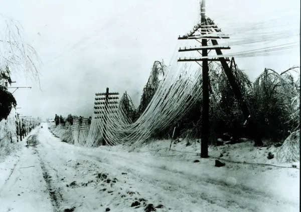
The morning hours are seeing the peak of the storm's intensity. Following an early morning start with heavy snow showers, the precipitation is transitioning into a treacherous mix of sleet and freezing rain. Temperatures are hovering right at the freezing mark, approximately 32°F, creating a high risk for significant ice accumulation. Forecasters expect up to half an inch of ice in some areas, which could lead to widespread power outages and downed tree limbs. Humidity remains high at 90%, making the morning air feel even more biting at a wind-chill-adjusted 29°F.
Afternoon: Transition Back to Snow
As we move into the afternoon, a fresh surge of colder air is expected to arrive. This will likely transition the freezing rain and sleet back into snow showers before the system begins to taper off. While the 100% chance of precipitation will decrease toward the evening, the damage to road conditions will already be done. Local authorities, including the Nashville Office of Emergency Management, have activated emergency operations and are urging residents to stay off the roads as accidents have already been reported across the I-40 corridor. All Metro Parks facilities and many local businesses have announced closures for the day.
Evening and Overnight: The Deep Freeze Begins
The real danger shifts from precipitation to extreme cold as the sun sets. The evening will see lingering snow showers ending from west to east, leaving behind an icy landscape. Temperatures are forecasted to take a massive nosedive, plummeting to a low of approximately 12°F to 14°F. A Cold Weather Advisory will take effect starting at midnight, as wind chills are expected to drop as low as -10°F. Wind speeds will remain steady around 10 mph with gusts up to 16 mph, creating life-threatening conditions for those without adequate shelter or power.
Key Alerts and Safety Reminders
- Winter Storm Warning: In effect until 6:00 PM Sunday. Expect significant icing and hazardous travel.
- Wind Chill Warning: From midnight tonight through Tuesday morning, with values reaching 10 below zero.
- Power Outages: High risk due to ice accumulation on power lines and trees. Keep devices charged.
- Closures: Metro Nashville Public Schools and most government offices have already confirmed closures for Monday, January 26.